


ISRO captured satellite images of the damage caused by the powerful earthquake measuring 7.7 in magnitude struck Myanmar on March 28, 2025.
The Indian Space Research Organisation (ISRO) on Monday released satellite images of the powerful earthquake caused by the 7.7 magnitude earthquake that struck Myanmar and rattled neighbouring countries on March 28, 2025.
The disaster caused widespread devastation, particularly near Mandalay, Myanmar’s second-largest city killing over 1,700 people, according to the latest input.
Cartosat-3, the space agency’s Earth imaging satellite, which can help with images at a resolution of less than 50 centimetres, managed to capture photos from an altitude of 500 kilometres above the Earth.
ISRO Releases Satellite Images
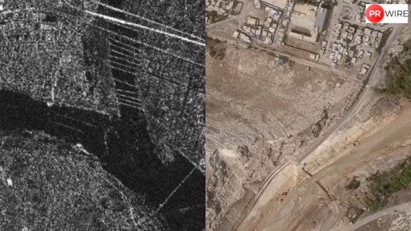
In the aftermath of the earthquake, satellite imagery from ISRO’s Cartosat-3 has provided crucial insights into the extent of the destruction. The released images show how a huge bridge over the Irrawaddy River collapsed. The damage to Mandalay University was also highlighted.

Irrawaddy River Floodplain

Mandalay University (Image: ISRO)
The earthquake resulted in catastrophic damage across multiple regions, leaving several people injured, while many lost their lives. Infrastructure such as roads, residential buildings, and historical landmarks also suffered severe destruction.
Notable damage was reported in Mandalay and the nearby Sagaing region. The images taken on March 29 revealed extensive damage to Mandalay’s infrastructure, including notable landmarks that suffered either complete or partial collapse.
Several major sites like the Mahamuni Pagoda and the historic Ava Bridge also collapsed. In addition to this, tremors were felt in Thailand, prompting emergency responses there as well.

Earthquake impact map of Mandalay city.
A state of emergency has been declared by Myanmar’s military government as rescue operations are underway to locate those trapped. According to reports, over 2,900 people have died, with thousands more injured.
India was one of the first countries to offer help and fly in rescue teams to provide assistance to Myanmar at this crucial time.
The article originally appeared on News18.